Pennsylvania's congressional and legislative votings maps are set for the next decade; they're much better than 2011. DTL's Citizens' Map is partly to thank.
When Pennsylvanians vote for their congressional representatives in the 2020s, they'll use this map. They'll vote for state representatives on this map, and state senators with these districts.
These districts are decidely better than what was passed in 2011. Why? This the most transparent mapping process in the history of the Commonwealth — not, as some elected officials have asserted, because of what happened inside the Capitol. Instead, it was the work of tens of thousands of Pennsylvanians that pushed for fairer, most compact maps that split fewer communities. It was citizen mappers, who threw open the curtains and turned on the lights.
The PA Citizens' Map Led by Example
In 2018, Draw the Lines PA held its first public mapping competition. 1,500 fully completed submissions later, Draw the Line presented the Pennsylvania Citizens' Map.
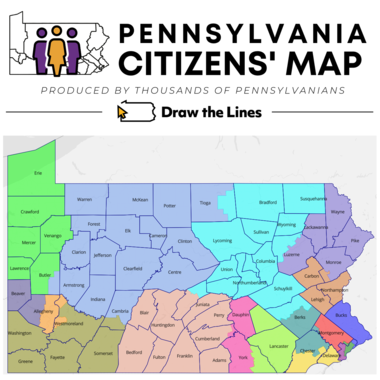
The Citizens' Map is a composite congressional map that met or exceeded the statistical benchmarks set by the 1,500 citizen maps. It reflects the values and community boundaries that mappers declared as important to them. The Citizens' Map, in effect, represents the everyday Pennsylvania mapper.
This is the first such map that has ever been created by such a large group of citizens. Governor Tom Wolf endorsed the Citizen’s Map, and Pennsylvania Supreme Court Justice Max Baer praised its creation: “I thought the Committee of Seventy and the methodology used here was really commendable… congratulations to all those involved in a really transparent process.”
Using the Citizens' Map, DTL calls on the General Assembly to produce a map for public comment.
Sorry, your browser is out of date
The web browser you are using is too old to view this site. Please update your browser or use Internet Explorer 11 or the current version of Microsoft Edge, Firefox, Chrome or Safari. Thank you!