Revising the PA Citizens' Map
January 12th, 2022
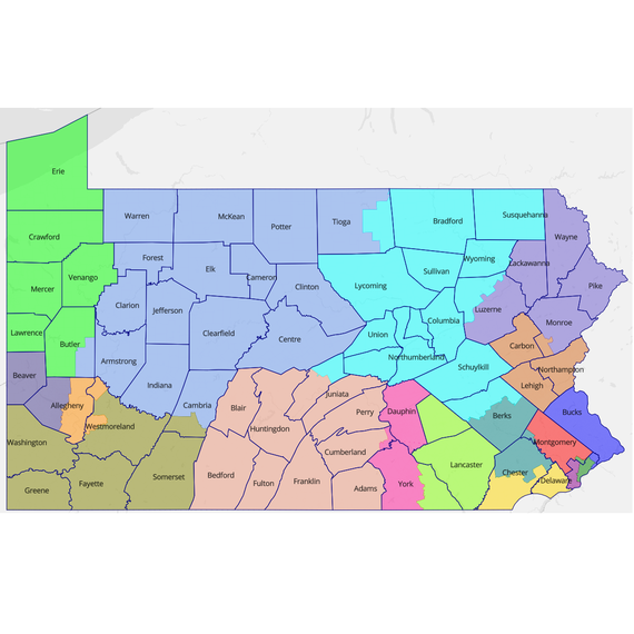
As we come into the homestretch of redistricting, Draw the Lines is excited to release an updated version of the Pennsylvania Citizens’ Map, a set of 17 congressional districts that has been developed using input and maps from over 7,200 Pennsylvanians.
Draw the Lines published the original version of the Citizens’ Map in September 2021. The map was accompanied by an extensive narrative that explained, district by district, the choices and tradeoffs embedded in the map. After the map was released, citizens were encouraged to make comments on the DTL website on what they liked and didn’t like about the map. Draw the Lines received 116 comments on the map. After taking those recommendations under advisement, Draw the Lines then produced a second, final version of the map.
Why did we revise the map?
Draw the Lines is modeling what we had hoped the General Assembly would have done -- produce a draft map using the public testimony they heard throughout the dozen hearings they held this year, and then engage the public to collect additional comments on that draft map before revising it. Unfortunately, the General Assembly’s chosen draft map was drawn by a single citizen, and executed a bait-and-switch without description before sending it for a committee vote.
The Citizens’ Map isn’t perfect, but it reflects a true public process. Further, it beats the map passed by the House on metrics across the board.
What changed in the new version?
The updated Citizens’ Map fixes three primary shortcomings of the first map.
First, by far the most common point of feedback we heard was from central PA residents, particularly those in Dauphin County, about how the original map diced up the Capital Region between three districts (10,11,13). Numerous commenters noted that Harrisburg has little in common with western counties like Blair and Bedford in CD13. The revised version keeps Dauphin County whole with much of York County in CD10, while including Adams County with the rest of CD13.
Second, we heard from nearly 10 Chester County residents that Coatesville and South Coatesville should be in the same district. They are now together in district 6.
Lastly, the original Citizens’ Map had a population deviation of four people. The revised version has a deviation of one person, in line with the most literal interpretation of the “One person, one vote” standard. We don’t agree with this form of false precision, but we acknowledge that without legislation codifying a larger allowable deviation, a map would face additional legal scrutiny.
What other comments did we hear?
There were two areas that drew commenters of varying perspectives: whether we should split the municipality of Pittsburgh, and if we should include Carbon County or southern Monroe County with the Lehigh Valley in CD7. Without a clear consensus, we defaulted to the original Citizens’ Map.
What’s next for the Citizens’ Map?
Today, the full House passed a bill containing the district lines passed out of committee before the holidays. It’s unclear if the Senate will be producing their own map or taking up the House plan. The governor has publicly stated that the House plan does not meet the redistricting criteria his advisory commission recently created.
Without an agreement between the General Assembly and the governor, the congressional map appears likely headed for the courts.
Mappers from Draw the Lines have filed an application to intervene in a Commonwealth Court case in which the Court has asked interested parties to present their credentials and a map for the Court’s consideration. If there is no agreement by the General Assembly later this month, it is possible that the Commonwealth Court will simply choose a map from among those submitted. Draw the Lines is one of about ten petitioners who will be filing their own maps. We certainly think ours is the most publicly-vetted of all of the maps that will eventually be submitted.
It remains possible that the State Supreme Court will exercise “extraordinary jurisdiction” and claim responsibility for drawing the map. Again, we’d encourage the Court to consider the Citizens’ Map as a viable option.