State Champion, Higher-Ed: Logan Ford, Mercyhurst University

About Logan Ford: I am a 4th year student at Mercyhurst University. As a life-long Pennsylvanian and student of political science, I wanted to make a map that is more compact and split fewer counties than the current map. My hope is that the next congressional map fosters more party cooperation and fosters policy that is more reflective of the state and the individual communities that make it up.
Judges' statement
Logan went above and beyond the competition requirements with outstanding metrics, clear and well executed values and a thoughtful essay that describes the personal impact of gerrymandering in his community. Logan earned additional points with us for his focus on community engagement, including his notable success in getting several elected officials to be endorsers.
Logan’s command of the subject and the mapmaking process was evident. The way this college student surmounted all the hurdles of time and intimidation to make contact with lawmakers shows his passionate commitment to the issue. He shows exactly how our mappers can take the initiative to leverage this competition to advocate for the end of gerrymandering.

Endorsements: 13
Personal statement
Living in Erie, I remember when my district was split as a result of gerrymandering. While the county theoretically had two members of Congress vying for its support, the pieces of Erie were only a portion of the bigger two districts.
If people identify with their county over their congressional district, the districts should reflect that. As a young voter, I have already seen how partisan politics can rip apart a purple state and nation. Heavily partisan districts lead to low voter efficacy, which may start a cycle of voter apathy and inaccurate representation in Congress.
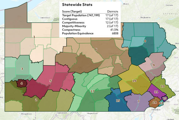
This map focuses on compactness, jurisdictional splits, and competitiveness. The state Constitution sets the first two of my priorities, saying districts should:
-
Be composed of compact and contiguous territory.
-
Avoid wherever possible dividing a county, city, incorporated town, borough, township or ward.
Compactness, when centered on communities of interest, keeps in the same district residents who claim the same area as “home.” I interviewed people across Pennsylvania so I could draw the districts to reflect the population's perception of “home.” I spoke mostly with educators and fellow students about the mapping process and my priorities.
Although not every educator or government official responded, I was thrilled to receive many endorsements, including from my state representative and state senator.
Sen. Laughlin (R-49) suggested that each time I refined a district boundary, I should alternate thinking as a Republican or a Democrat to try to increase competitiveness. Though I believe that competitive elections yield more moderate candidates and policy- which may work to heal the partisan rift in our state and country - it is not the burden of the state or its citizens to ensure competitiveness above all else.
Supreme Court precedent set by Freeman v. Pitts and Parents v. Seattle School District regarding racial integration in schools can be more generally applied to political party affiliation: It is up to the candidates to be the best representative possible of their constituents, regardless of potential clusters of like-minded voters. The districts of Philadelphia could only be made competitive by sacrificing their compactness and breaking additional county lines.
This map was challenging because the foundational values often conflicted with each other. These conflicts raised questions such as: Do I split this community to make two more competitive districts?
In an ideal world, the candidates would work to be competitive and represent the people before we reached the point where districts had to be drawn solely for competitiveness.
The map is a well-rounded representation of compactness, minimal jurisdictional splits, and competitiveness without sacrificing one for any of the others.
