Estella Stein (Philadelphia) - Honorable Mention, PA House

About Estella: I am a junior at The Baldwin School in Bryn Mawr, PA. At school, I'm a head of Drama Club and Creative Writing Club, and am deeply involved in design work for our Theater Department. I also love history and statistics, and want to thank my teachers, Ms. Young and Dr. Biss, for motivating me towards this cause by so passionately teaching us the history of gerrymandering in our state and the math behind how we elect officials.
Judges' Statement
Estella did a fantastic job putting together a PA House map, which is not an easy task for an experienced mapper, much less a high school junior. Fantastic work! She combined a map with strong metrics with a broad slate of endorsements to earn honorable mention honors.

Personal Statement
If we have been made aware of anything over the past year, it is that minority groups require government representation to continue on the path to equity and justice. I entered into my school’s map-making course set on finding a solution to ease the pain of underrepresentation, and naively believed that it would be easy to find. Where the government had placed emphasis on preserving counties and increasing competition, I would be able to give the oppressed minority resident reassurance that their vote would count. My goals were ambitious and inspired, but oh, were they misinformed.
On the first day, the set of demographics placed in front of me was challenging to comprehend. I stared at it, briefly tried to manipulate it, and remarked out loud, “Pennsylvania is a pasty white state.” This, of course, is not true. Racial and ethnic minorities have a long history of migration, settlement and oppression here, but I was shocked at the already-existing compactness of these groups, creating select locations with a population that could counteract the blinding whiteness surrounding them. Within our class, we discussed how racial gerrymandering makes snaking shapes in order to pack minority populations from across a state and contain them in a district, and Pennsylvania didn’t have to work hard to do this.
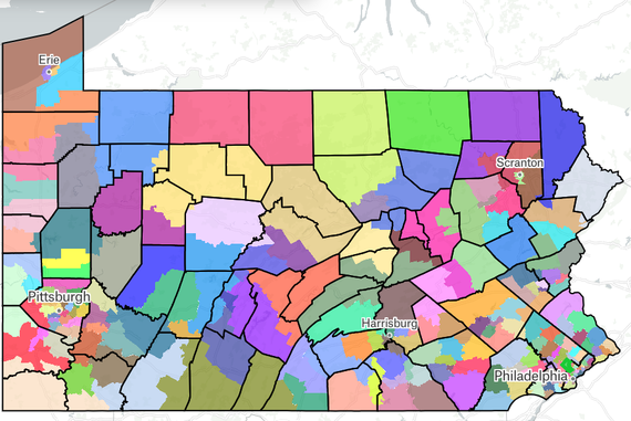
In my opinion, the government has a duty to empower minority populations after centuries of restriction and abuse, and this time around, I was the government. For these reasons, I made the decision to use the 203-district House of Representatives map rather than the 17-district Congress map, which frustrated me to no end; it was more conducive to both my goals in representing minorities and my personal thoughts and ways of problem-solving (I tend to work well with small details). This was extremely beneficial to my aims, as I ended up finding majority-minority districts besides Philadelphia that were hidden in a larger white county population. I had to sacrifice much of my competitiveness and slight population equivalence in certain districts, but I achieved high levels of compactness and was able to create extra minority-majority districts in Pittsburgh, Harrisburg, Lancaster, Allentown, Reading, Chester and Darby. In addition, minority impact was increased for districts in 13 counties. In this process, I uncovered minority populations who would have no chance of making an impact on the Congressional map.