Personal Statement
In the one-week “Math, Map, and Democracy” interdisciplinary course, I learned about gerrymandering and was shocked by its impact on the elections. Splitting counties, separating communities, or dividing cities cause residents who live on the opposite sides of the street or in one neighborhood to be in different congressional districts. They may have to vote for different representatives and might not want to vote for the representative who doesn’t represent them. The single neighborhood that joins another district may feel that they are excluded from their county. It would also be a practical issue that driving a lot further to vote may be inconvenient. When redistributing the congressional district, my primary goal is to minimize the country split.
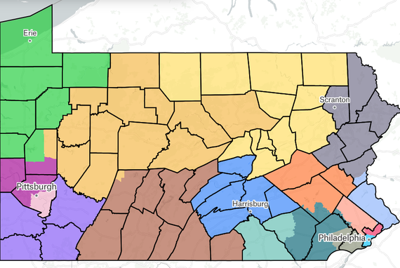
I started drawing the map only using counties. After dividing up the state into 15 areas, I split the two largest cities, Philadelphia and Pittsburgh, to reach 17 areas. With a general arrangement of the 17 districts on the map, I then worked on population equivalence. I observed the population deviation between two neighboring districts, and if their net deviation was close to 0, I split the county that borders the two districts. In this process, I moved some counties to new districts to fit the net deviation and create higher compactness. After adjusting the population deviations, 3 of the districts didn’t contain a single county that was split, and among the 50 counties of Pennsylvania, only 9 were split into different congressional districts. My map also had a compactness of 37% while each district was contiguous.
As I decided to focus on minimizing county splits, other requirements, especially population equivalence and competitiveness, had to be sacrificed. However, I was able to put all 17 districts in the range of plus-minus 0.5% population difference. Although some counties had to be split to reach population equivalence, understanding population equivalence shouldn’t be a reason for more county splits and no map was perfect, I continue to prioritize my goal of minimizing county splits.
Drawing the congressional districts allowed me to learn about the state’s geography including the locations of the population centers and minority groups. I believe the knowledge about gerrymandering and geography will always be valuable, and I was grateful for Draw the Lines for this meaningful experience.